
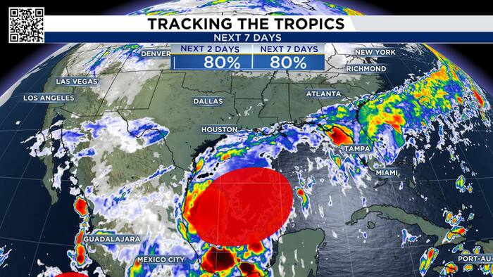
A tropical system is getting better organized in the Gulf and let’s dive into the latest data and most importantly, explain what it could mean for Southeast Texas.
Right now, Invest 92L has a 90% chance of becoming a tropical storm in the next two days. If it does strengthen into a tropical storm, the next name on the list is Isaias (ees-ah-EE-ahs).
The hurricane hunters are flying into the storm Tuesday morning, which should give us much better analysis (do we have a closed low, new atmospheric conditions, etc.) But the early guidance is beginning to give us a pretty good idea of where this system is headed.
And the good news for Houston is this...
It is not our storm. This the European AI forecast showing the center of circulation between Louisiana and Florida.

There is an old meteorological saying that once the first real cold front moves through Southeast Texas, hurricane season is essentially over for us.
Obviously, hurricane season doesn’t officially end until November 30. But there is some meteorological truth behind the saying.
Think of that front as a brick wall.
Once the front moves through, the winds associated with it can block tropical systems from moving north into Southeast Texas. Instead, storms get steered either toward the west or, more commonly this time of year, toward the east.
That’s exactly what we’re seeing with this system.

The system is expected to spend quite a bit of time hanging around the Bay of Campeche before finally moving. And here’s something important: the center of the circulation isn’t necessarily where the biggest impacts will be. As the system eventually moves north and east, the heavier rain shifts toward Louisiana and Florida. Some of the latest guidance is showing 5 to 9.5 inches of rain from Louisiana into parts of Florida.
Houston? Not much.
I’m putting a 20% chance of rain into the forecast Friday through Sunday because a few rainbands could potentially reach Southeast Texas, especially if the system becomes larger and less organized. But overall, I expect the heaviest rain to stay well east of us.

This is where things get interesting.
The Gulf is incredibly warm right now, with water temperatures running roughly 84° to 88°. Those are record-setting warm temperatures in the Gulf, and warm water is certainly fuel for a tropical system.

Right now, temperatures and wind shear are both favorable for development.
Some of the guidance even shows a 30% to 40% probability of hurricane-force winds in the Bay of Campeche by Friday morning.

But that doesn’t mean we should expect a hurricane near Houston.
As the system moves north and east, it is going to run into increasing wind shear.
Wind shear is essentially a difference in wind speed and/or direction with height. Too much shear can tilt and disrupt a tropical cyclone, essentially ripping it apart.
In some circumstances, shear can actually help ventilate a storm and maintain its strength. But in this case, the increasing shear looks like another factor that will work against the system as it moves northeast.
So even if this system briefly becomes a hurricane over the Gulf, I expect it to weaken as it moves into stronger winds aloft.

And that brings us back to our cold front. The front and the changing wind pattern are helping steer this system away from Southeast Texas.
I thought this statistic was fascinating. If you look at Texas hurricane landfalls from 1851 through 2025, Texas has had only three hurricane hits in the month of October.
One of them was Hurricane Jerry on October 15, 1989. Jerry made landfall at Jamaica Beach as a Category 1 hurricane and holds the distinction of being the latest hurricane landfall on record for both Texas and Southeast Texas.
Why does that matter?
Because by mid-October, the weather pattern across Texas is changing.
Those cold fronts become more frequent, and they can act as a barrier that keeps tropical systems from moving into Texas.

Florida is a completely different story.
If you look at the same historical data, Florida’s hurricane activity really increases from September to October.
That’s an important reminder that hurricane season doesn’t end everywhere at the same time. The atmospheric steering patterns change dramatically as we move deeper into fall.
And we’re seeing that play out right now with this Gulf system.


